What to know as "super El Niño" conditions take shape
El Niño has reached "super" status this year, with sea surface temperatures in the tropical Pacific rising more than 4 degrees Celsius above average, according to NOAA's Climate Prediction Center.
The National Oceanic and Atmospheric Administration's Climate Prediction Center officially announced Thursday that El Niño conditions have intensified and continue to strengthen. The agency warns that its effects through next spring may be considered historic, with sea surface temperature anomalies in the tropical Pacific exceeding 4 degrees Celsius as of November 12.
El Niño is a climate pattern characterized by warming waters in a specific region of the Pacific Ocean near the equator, occurring every two to seven years and typically lasting nine to 12 months. When active, it causes global temperature increases and significantly alters weather patterns worldwide.
Global impacts
Researchers at the University of Chicago estimated that 451,000 additional people worldwide will die during this year's El Niño compared to a typical year due to excessive heat exposure. The phenomenon affects different regions in contrasting ways, with northern South America and central Africa experiencing drier conditions, while eastern Asia and southern South America face increased precipitation.
The mixed impacts on Central and South America have already devastated agriculture and prompted multiple countries to declare national emergencies. While some areas may benefit from improved drought conditions, others face severe flooding risks.
Hurricane seasons
El Niño has had dramatically different effects on hurricane seasons in the Atlantic and Pacific oceans this year. In the Atlantic, it has suppressed tropical storm and hurricane activity to record lows, while simultaneously fueling an exceptionally intense Pacific season with 32 named typhoons so far.
El Niño has opposite effects on the Atlantic and Pacific hurricane seasons, decreasing tropical activity in one and ramping it up in the other.
The Western Pacific has seen Super Typhoon Sinlaku in April and Super Typhoon Champi in October, both reaching Category 5-equivalent strength with sustained winds of up to 185 mph. The Eastern Pacific has recorded 21 named tropical systems, some bringing large waves that eroded beaches along the U.S. West Coast.
Future outlook
Scientists note that El Niño events are becoming stronger and longer over time, with the current conditions linked to 2026's record-breaking global temperatures.
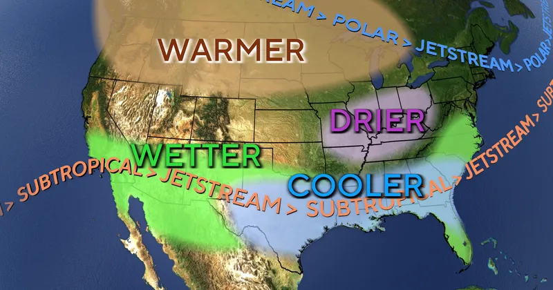
In North America, the southern portion is expected to experience wetter conditions with more frequent storms, while the northern regions will likely see milder weather with less precipitation. The fishing and agricultural industries, as well as utilities dependent on rainfall and wind power, will continue to face tangible consequences of these climate shifts.
Related
